Magnetic north pole changing and how effect on Navigation and GIS
January 13, 2019
Edit
Magnetic north pole changing and how effect on Navigation and GIS
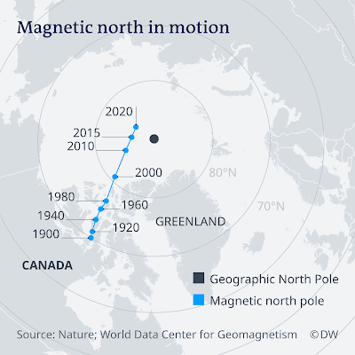
Scientists were set to release a new World Magnetic Model after accelerating changes in earth's magnetic field, but the US government shutdown has stopped them for now. Navigation as we know it could be in jeopardy.
The World Magnetic Model is updated every five years to account for shifts to the field and the last one took place in 2015. However, in 2016, part of the magnetic field "temporarily accelerated deep under northern South America and the eastern Pacific Ocean," according to Nature.
By 2018, scientists at US National Oceanic and Atmospheric Administration and the British Geological Survey realized they needed to release an updated WMM because it had become "so inaccurate that it was about to exceed the acceptable limit for navigational errors."
The wandering pole is driven by unpredictable changes in liquid iron inside the Earth.
Due to the US government shutdown, scientists have been unable to release the updated WMM. Instead, they have pushed back the date to January 30, hoping that the government will be running by then. But it's unclear if that will be the case.
CORE OF THE MATTER
Why the magnetic field is shifting so dramatically is unknown.
“Geomagnetic pulses, like the one that happened in 2016, might be traced back to ‘hydromagnetic’ waves arising from deep in the core,” Nature reports. “And the fast motion of the north magnetic pole could be linked to a high-speed jet of liquid iron beneath Canada”.
This fast-flowing molten river appears to be weakening the magnetic influence of the iron core beneath North America.
“The location of the north magnetic pole appears to be governed by two large-scale patches of magnetic field, one beneath Canada and one beneath Siberia,” Phil Livermore of the University of Leeds told an American Geophysical Union meeting. “The Siberian patch is winning the competition.”
And, as global warming opens up more shipping lanes to the north of Russia and Canada, this presents a potentially deadly problem.
“The fact that the pole is going fast makes this region more prone to large errors,” says Arnaud Chulliat, a geomagnetist at the University of Colorado Boulder and NOAA.
'Your orientation'
While location can be tracked using GPS technology, WMM provides orientation for aircraft, naval vessels and even smartphones. "Your orientation, the direction you are facing, comes from the magnetic field," said James Friederich, a scientist at the US National Geo-Spatial Intelligence Agency, in 2014 ahead of the last WMM update.
"Our war fighters use magnetics to orient their maps. Your smartphone camera and various apps can use the magnetic field to help determine the direction you are facing. All of these examples need the WMM to provide your proper orientation."
But scientists are still in the dark concerning the acceleration of changes in the magnetic field. The shifts are fueled by changes in currents — like those of the ocean — of molten iron in the earth's core. But why they're accelerating now remains a mystery.
